Introduction
The essentials of obligatory Voyage Planning were discussed in Risk Bulletin No. 27. This Risk Bulletin No. 33 is focused on the importance of assessing chart data reliability as a key component of the Voyage Planning process and grounding loss prevention. The goal is to avoid or at least minimise the risk of grounding and resultant losses inclusive of cargo damage, oil pollution, crew injury and associated salvage and/or wreck removal costs.
Background
Vessel grounding and loss incidents continue to occur. As shown by flag state casualty investigations, a significant number of them are caused by inadequate voyage planning prior to the start of the voyage. An example of such a voyage planning failure (exacerbated by poor watchkeeping), is provided by the Maritime NZ report on the MV Rena grounding. This incident generated one of the costliest P&I claim incidents ever recorded.
The MV Rena grounded on a clearly charted reef and the master and 2/O were subsequently imprisoned. However, uncharted obstruction groundings present a more complex situation. Can the navigator be at fault for what he/she literally cannot see? And can such incidents be avoided? The answers to these two questions lie in chart data reliability and the obligation of all navigators to be aware of potentially serious chart data deficiencies.
Chart Production and Reliability Standards
The advent of the GPS system, satellite photography and the development of wide beam bathymetric water depth measurement have led to a substantial improvement in the accuracy and reliability of marine charts. However, the task of observing and measuring what is underwater and invisible to the human eye is technically far more difficult than measuring and mapping the earth’s land surface. As a result, no marine chart can yet be considered as being 100% reliable. However, some charts are closer to high levels of data accuracy and associated reliability and confidence than others. How then does the navigator distinguish between highly reliable and less than reliable charts?
The key to safe navigation lies in the understanding and application of the chart reliability and confidence factor to the Voyage Planning process. This requires a working knowledge of how chart data is obtained, charted and then categorised by chart publishers to indicate reliability in an objective and standardised manner. A clear and practical guide to these processes is provided by the Australian Hydrographic Office (AHO) 10-page Guide Accuracy and Reliability of Charts.
The AHO Guide explains the relationship between chart reliability and confidence along with the development of hydrographic methodologies and their related and now much improved accuracy. It also explains the concept of Categories of Zones of Confidence (CATZOC) which was developed by the International Hydrographic Office (IHO) for use as an information overlay to Electronic Charts (ENC) e.g. Electronic Chart Display and Information Systems (ECDIS).
Importantly, the CATZOC process (as briefly explained below) has also been applied by many (but not yet all) coastal state chart publishers of Paper Navigation Charts (PNC) by incorporating printed CATZOC Diagrams.
Brief Introduction to CATZOC
Prior to the creation of CATZOC, the assessment of the reliability and confidence which could be placed in a PNC was more of an art form than a science. Navigators were aware that attention should to be paid to the date at which the chart data was ascertained. In general, the older the data was and the more primitive the systems used for depth measurement and position finding, the less likely the chart was to be reliable. In some cases, a chart reliability caution would be printed on the chart by the publisher. However, there was no internationally agreed standard to provide uniformity to this process.
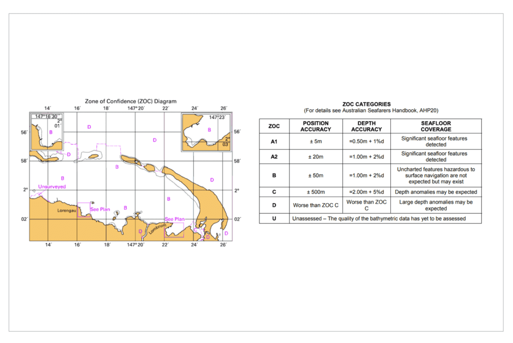
When ENCs were first developed, the IHO realised that an internationally agreed chart reliability and confidence standard was essential. The CATZOC system was then created and has since been adopted by all coastal state members of the IHO. A CATZOC chart reliability/confidence table (as extracted from the Australian Hydrographic Office (AHO) Mariners Handbook ) is shown as below:
| Category | Confidence level | General description – survey characteristics |
| A1 | Significant seafloor features detected and depths measured. | High position and depth accuracy achieved using Differential Global Positioning System (DGPS) and a multi-beam, channel or mechanical sweep system. |
| A2 | Significant seafloor features detected and depths measured. | Position and depth accuracy less than ZOC A1, achieved using a modern survey echo-sounder and a sonar or mechanical sweep system. |
| B | Uncharted features, hazardous to surface navigation are not expected but may exist. | Similar depth accuracy as ZOC A2 but lesser position accuracy than ZOC A2 (generally pre-dating DGPS), using a modern survey echo- sounder, but no sonar or mechanical sweep system. |
| C | Depth anomalies may be expected. | Low accuracy survey, data collected on an opportunity basis such as soundings on passage or low accuracy given due the passage of time. |
| D | Large depth anomalies may be expected. | Poor quality data or unsurveyed. |
| U | Unassessed. | The quality of the bathymetric data has yet to be assessed. (Mariners should assume poor data quality until the area has been assessed). |
©Commonwealth of Australia 2020. All rights reserved.
It can be seen that Categories A1, A2 and B indicate the highest levels of chart reliability and confidence. On the other hand, Categories C, D and U indicate that, in sequence, caution, extreme caution and ‘no go’ should be exercised.
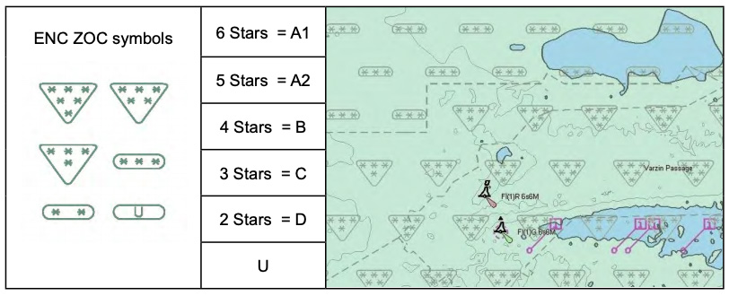
The CATZOC categories are available to an ENC navigator by way of an electronic overlay which may be selected at will. An illustration of this (also extracted from the AHO Mariners Handbook) is shown below. It will be noted that Star rating symbols are used in place of CATZOC alphanumeric A1 through D with an Unassessed rating displayed as U. As charts are almost invariably a compilation of survey data obtained at different times and by different methods, it will also be seen that the CATZOC symbols and data confidence levels fluctuate over the face of the chart.
©Commonwealth of Australia 2020. All rights reserved.
Regulatory Requirement to Use ENC (ECDIS) in International Trade
The navigational equipment requirements (inclusive of updated charts and publications) for all ships over 500GT in international trade are set out in SOLAS Chap. V, Reg. 19, Para 2.10. SOLAS requires that all passenger ships over 500 GT and all ships, other than cargo ships and tankers under 3,000 GT, must now be fitted with ECDIS. Paper charts or a second ECDIS unit with an independent power supply must also be provided as a back-up. As a consequence, there are only very limited exemptions (i.e. passenger vessels under 500 GT and cargo ships and tankers under 3000 GT) from the SOLAS requirement to fit ECDIS on board vessels in international trade.
Regulatory Entitlement to Continue to Use PNC in Domestic Trade
All vessels engaged in domestic trade, regardless of type or size (i.e. non-SOLAS vessels), are regulated by national flag rules. An example of this is provided by the Indonesian Non Convention Vessel Standards and Guidelines (NCVS) Ed. 2012, Chapter 3, Section 27, Navigation Equipment.
Para (g), Section 27, confirms the obligation to carry up to date paper navigational charts (PNC) and publications (e.g. Sailing Directions/Pilot Books) on board vessels in “near coastal trade”. Para (g) also provides the non-mandatory option to install and use ECDIS, subject to this system being provided with PNC or a separate and independent ECDIS back-up unit. As such, Indonesian vessels in domestic trade are not obligated to be fitted with ECDIS equipment and may continue to navigate using PNC and paper publications only.
Other flag states may of course have different NCVS requirements in relation to chart and publication requirements for domestic trade vessels. Members should therefore always check with their flag state authority to obtain specific advice and confirmation of compliance.
ENC or PNC: what’s best for assessing chart reliability & confidence?
In terms of assessing chart reliability and the confidence, ENCs have an advantage over PNCs in that ENCs provide an integral CATZOC overlay to inform and assist the navigator. However, the data on the ENC will be no better than the PNCs from which it has been copied. Thus, if the PNC equivalent is printed by the publisher with an inset CATZOC diagram (as illustrated at the top of this RB), the PNC navigator will not be disadvantaged when assessing chart reliability. Unfortunately, not all PNCs published by IHO member states are printed with CATZOC diagrams as this this is not yet an IHO requirement.
ENC and PNC Voyage Planning
Regardless of whether ENCs or PNCs are used for Voyage Planning (VP), it is essential that every vessel’s ISM Code (or NCVS equivalent) SMS procedures set out the details of how the VP process is to be accomplished. These details should include an obligation for the navigator and master to consider and assess the reliability and CATZOC for all of the charts to be used for the planned voyage and then take appropriate precautions.
Navigators using ENCs will likely be using an ECDIS system to accomplish VP. Some of these systems use built-in VP software and sometime it is an add-on. The first issue to be aware of is that not all VP software incorporates an automatic reference to CATZOC data as a part of the VP process. The second issue is that the VP software may or may not make reference to all of the essential information contained within relevant Sailing Directions (Pilot Books) publications. Navigators using ENCs for VP must therefore be very careful to ensure that these two potential shortcomings have been recognised and dealt with.
Navigators using PNCs will need to rely on the CATZOC diagrams printed on the charts to be used during the voyage. If no CATZOC diagram is provided, then the navigator must first look at the survey date and any related information printed on the chart. The older this date, then – as explained in both the AHO Guide and AHO Handbook Chapters 12 & 13 – the greater the likelihood that the depth and position of charted obstructions is unreliable and that dangerous obstructions may have been left uncharted. The second thing to be done is to refer to the relevant Sailing Directions to obtain specific advice on chart reliability and confidence in that area.
Conclusion and Takeaway
Very few commercial vessels are fitted with forward depth sensing sonar. As a consequence, the safe VP and avoidance of grounding by most vessels depend upon the reliability of the charted information available to their masters and navigators on the depth of water which will lie beneath their ships’ keels while on passage. If this information is inaccurate, the results – as illustrated by numerous charted and uncharted obstruction groundings worldwide – can be both catastrophic and very costly.
There is no simple or ‘quick fix’ solution to the problem of chart reliability which will no doubt require many years of on-going work by the IHO and the active cooperation of IHO members to resolve. Meantime, Members need to be alert to this significant hazard and ensure that their masters and navigators take appropriate care during both the VP process and while on passage. MM’s six recommendations to Members are set out below:
- All charts for the voyage must be the latest editions and updated to the latest Notices to Mariners (NTMs). This information is available on the internet e.g. the UKHO Chart Catalogue is available on-line and the latest UKHO NTMs are posted on their website on Thursday of every week. Similar information is available on the Indonesian Navy HO (Pushidrosal) website.
- SMS procedures relating to VP should be checked to ensure that they contain a specific requirement for navigators and masters to:
- Make a formal assessment of the reliability of all charts – whether ENC or PNC – by reference to both CATZOC data and relevant Sailing Directions.
- Keep all planned course tracks inside the limits of any Recommended Routing either printed on the charts to be used or as contained in relevant Sailing Directions/Pilot Books.
- If PNCs are being used, then each chart must be checked to ensure that it is referenced to WGS84 geographical datum so as to match GPS receiver standard datum settings. If any chart is not referenced to WGS84, then a warning to all navigators must be clearly marked on that chart together with position discrepancy advice.
- If PNCs are being used, then charts to be used for coastal passages and port entry must be at the largest scale available from chart publishers to ensure full SOLAS or NCVS navigational equipment compliance.
- If CATZOC data and/or Sailing Directions indicate that the reliability and confidence in any charted area on a VP route is at CATZOC ‘C’ (3 Stars) or below (i.e. a passage of chart confidence concern), then appropriate due diligence precautions must be implemented and alerted to all navigational officers. Examples such of such precautions include:
- Alternative routing to a possibly longer but more reliable route.
- Day light transit only and posting of dedicated lookouts during passages of concern.
- Speed reduction during passages of concern.
- Presence of the master on the bridge at all times during passages of concern and particularly in CATZOC ‘D’ or ‘U’ areas.
- Consideration should be given to incorporating a specific reference to the AHO Guide in the aforesaid SMS procedures along with an annexed copy of the AHO Guide 10-page explanatory text. Masters and navigators should also be referred to the detailed advice contained in the AHO Mariners Handbook at Chaps.12 and 13.
Maritme Mutual would like to thank the following marine consultants and surveyors for their valuable advice and assistance in the preparation of this Risk Bulletin:
- Capt. Bruce Ewen, Director, Aulis Insights Pte Ltd, Singapore
- Capt. Sonny Sonjaya, CEO & Chief Technical Adviser, PT Aurora Samudera Perdana, Jakarta
- Capt. Taufik Hidyatullah, PT Camarindo, Jakarta
Note: This Bulletin contains references to the Mariners Handbook for Australian Waters 5th Edition. At the time of publication, this is the most recent edition of the handbook, however, we advise to always check if a more recent version of the handbook is available.